
ARCHEOASTRONOMIA LIGUSTICA
Pubblicato in: Atti del XI Convegno Società Italiana di Archeoastronomia, Il dentro e il fuori del cosmo. Punti di vista per interpretare il mondo. Bononia University Press, Bologna, 2013, pp. 77-84, ISBN 978-88-7395-866-6.
Printed in: Atti del XI Convegno Società Italiana di Archeoastronomia, Il dentro e il fuori del cosmo. Punti di vista per interpretare il mondo. Bononia University Press, Bologna, Italy, 2013, pp. 77-84, ISBN 978-88-7395-866-6.
ARCHAEOASTRONOMICAL SURVEYS IN LOTHAL (INDIA)
Mario Codebò
Archeoastronomia
Ligustica; S.I.A.; S.A.It.; info@archaeoastronomy.it
Henry
De Santis
Archeoastronomia
Ligustica; S.I.A.; S.A.It.; info@archaeoastronomy.it
Dennys
Frenez
Dip.
Storia, Culture, Civiltà (Sez. Archeologia) - Università di Bologna; dennys.frenez@unibo.it
Abstract
The
Indus Civilization harbour-site of Lothal is located within a small doab created by the confluence of the
Bhogavo and Sabarmati rivers about 30 km before their flowing into the Gulf of
Khambhat and the Arabian Sea (Gujarat, India). The urban settlement (ca. 10 ha)
consisted of an acropolis with the public and the ritual buildings and a lower
town with the residential and the craft areas. A huge brick-lined water basin
(220x40x4 m) - variously interpreted as a water supply tank or a dockyard - has
been discovered immediately East of the site.
The
acropolis and the dockyard were built matching the four cardinal marks, while
the lower town has different orientations.
In our
report we show and discuss the results of our astronomical surveys on these
ancient architectures.
1. Archaeological
data (by Dennys Frenez)
The archaeological site of Lothal (22°31’22.97” N / 72°14’56.10” E)
covers about eight hectares and was discovered in 1954, as the result of a
systematic village-to-village archaeological survey of the Saurashtra-Kathiawar
Peninsula in the State of Gujarat, India. The site is located on a natural
elevation within the small doab created by the confluence of the Bhogavo
River from North-West, and the Sabarmati River from the North, about 25 to
About one third of the site mound has been excavated and documented in
detail by S.R. Rao the Archaeological Survey of India between 1955 and 1962. An
enormous corpus of data about the structural setting of the site and its
material culture has been published over almost thirty years by Rao in
different books and papers, but mostly in the official report of the
excavations, published by the Archaeological Survey of India in two separate
volumes: volume 1, about the environmental context and the structural features
of the site (Rao 1979), and volume 2, which illustrates in detail the material
culture found at Lothal (Rao 1985).
The excavations carried out by Rao disclosed an urban settlement clearly
ascribable to the Indus Civilization, which flourished on a local pre-Harappan
chalcolithic site (Rao 1979: 24-25). The site occupation was divided into two
main periods separated by a short break. Period A is dated from about 2450 to
1900 BC, perfectly matching to Phases 3B and
At Lothal, archaeologists found an ‘acropolis’ raised upon a system of
artificial box-like platforms that supported the public and the ritual
buildings, and a ‘lower town’ with the residential and craft areas. However,
the most impressive structure is undoubtedly the huge baked-brick-lined water
basin excavated by Rao immediately east of the site. According to the excavator
(Rao 1979: 63-64, 123-134 and fig. 19), it was roughly trapezoidal, measuring
The debate about the function of this unique structure is still open and
the different possible interpretations highly influenced several other central
archaeological questions about the site. The basin was originally interpreted
by Rao as a dock for small boats that reached Lothal from the Gulf of Khambhat
through the Sabarmati-Bhogavo river system (Rao 1979: 125-134). This hypothesis
was supported by several scholars. Later, other scholars considered it just a
big reservoir for irrigation and/or drinking water, while others just rejected
both theories without proposing any solid alternatives. In a recent paper, Rear
Admiral Retd. S.C. Bindra (2003) evaluated all possible interpretations
proposed of the Lothal basin in great detail. Considering the technical
features of the structure and the rough environmental data available at the
moment, he rejected the possible use of the basin for storing fresh water, in
favor of its interpretation as an inland tidal dock (Bindra 2003: 16-18).
2. The Indian-Italian Joint “Lothal Revisitation Project” (by Dennys Frenez)
The Bhogavo-Sabarmati tidal plain north of the Gulf of Khambhat, where
Lothal is located, is a very dynamic geographical compound affected by heavy
siltation, fluvial erosion and deposition. Consequently, the modifications
undergone during the past five millennia may have considerably modified the
coastal configuration and the main hydrological drainage system of the region
(Khadkikar 2006; Khadkikar et al.
2004a; 2004b; Nigam 1988; 2005; 2006; Nigam et al. 1990; Nigam and Hashimi 2002). Moreover, a comprehensive detailed paleoenvironmental reconstruction
has to consider also the particular features of the Sea level fluctuations in
the area. The Gulf of Khambhat is, in fact, a macrotidal monsoonal system affected
by a high tidal range that reaches up to twelve meters (Deo et al. 2011: 138; Nayak and Shetye
2003).
The geomorphological framework is therefore of fundamental importance to
validate Rao’s interpretation. The geographical and ecological evolution of the
area was closely affected by the Holocene climate cycles that alternated
periods of marine transgression and ingression, which determined a continuous
shifting of the shorelines along the Bhogavo-Sabarmati tidal plain (Mancini et al. 2010). According to several
scholars (Hashimi et al. 1995; Rao et al. 2003; Mathur et al. 2004), the sea level in the eastern Arabian Sea was ca.
During the second half of the 3rd millennium BC, the level of
the Eastern Arabian Sea was ca. +
On these bases, the ‘Lothal Revisitation Project’ was proposed to be
carried out in direct partnership between the Department of Archaeology of the
University of Bologna and the Archaeological Survey of India, Ministry of
Culture, Government of India, with the technical collaboration of the Department of Earth Sciences and Environment of the University of
Bologna, headed by Prof. Giovanni
Gabbianelli.
The Lothal Revisitation Project
was mainly designed as a geoarchaeological project, combining remote sensing
and field activities. In particular, non-invasive geophysical prospections have
been proposed to detect different natural and artificial subsoil features,
complemented by series of core-drillings to determine the shifting of
paleochannels and shorelines (for the theoretical background of the proposed
geophysical methods and examples of case-studies, see Campana and Forte 2006;
Campana and Piro 2009; Khadkikar 2006; Khadkikar et al. 2004a; 2004b).
The research program was designed to investigate in detail the
comprehensive archaeological compound, including the urban settlement configuration
and the surrounding environment, through a close and continuous interaction
between archaeologists and teams of geologists, geomorphologists, geophysicists
and other specialists of environmental sciences, in order to reconstruct the
paleogeography around Lothal during the Late Mid-Holocene (ca.
The ‘Lothal Revisitation Project’ was also planned as a comprehensive
program of mutual exchange with an intensive program of training, in order to
activate the transfer of the most advanced and innovative methods and
techniques for the application of remote sensing, digital documentation and
geophysical prospections in archaeology through field activities, lectures and
conferences. Moreover, special advisers with recognized experience in museum
sciences, archaeological site conservation and design of open-air
archaeological parks are continuously assisting the Indo-Italian team for
specific actions.
3. The
archaeoastronomical survey (by Henry De Santis)
The urban settlement of Lothal (ha 10
approximately) consists of an acropolis with warehouses, public and ritual
buildings and a lower town with the residential and the craft areas.
A huge brick-lined water basin (m. 220x40x4) -
variously interpreted as a water supply tank or a dockyard - has been
discovered Eastward of the site immediately.
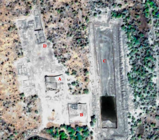
A acropolis; B warehouse block; C water basin; D Lower Town.
The following measures of azimuth have been taken
since 5 to
Internal structures of the acropolis:
azimuth N-S
358°53' « 178°53';
azimuth E-W 88°58’ « 268°58'.
Internal structures of the warehouses block:
azimuth N-S 359°20' « 179°20';
azimuth E-W 89°28' « 269°28'.
Perimeter walls of the warehouses block:
azimuth N-S 357°24' « 177°24';
azimuth E-W 88°30' « 268°30'.
Water basin:
azimuth N-S 357°54’ « 177°54';
azimuth E-W 91°49' « 271'49'.
Lower town:
azimuth N-S 347°12' « 167°12';
azimuth E-W 74°36' « 254°36'.
4.
Archaeoastronomical hypotheses (by Mario Codebò)
It is
sure that the axes which we measured in Lothal - except the low city - point to the four cardinal
points with an average deviation (both eastward and westward) of 1.6° from the
meridian. This little deviation coincides with Thuban’s (α Draconis) maximum digression
in 2450 B.C. well enough.
Thuban’s
equatorial coordinates FK4 B1950 are: α
1)
acropolis: 1°07’;
2)
warehouses: 0°40’;
3)
warehouses’ boundary walls: 2°36’.
The
azimuth of the lower city is
completely different: 12°48’ from meridian and 10°40’ from Thuban’s maximum digression. Certainly, the low city had no astronomical alignments.
There
are other methods to obtain an orientation toward North in absence of a Polar
Star:
1) using
the shadow of a gnomon (low accuracy);
2) using
the transit of the Sun across the local meridian (low accuracy);
3) using
the so called Indian circle (high
accuracy) (Romano 1992, p. 89);
4) using
an artificial horizon to observe towards North the medium point of the rising
and the setting of a circumpolar star (high accuracy) (Romano 1992, pp.
188-189).
Methods
No 1 and No 2 are almost inaccurate; this inaccuracy may be in accordance with
a very different azimuth from 360°. Methods No 3 and No 4 have a good accuracy
but in this case the azimuth of the alignments would be precisely 360°-180°. A
difference between the meridian and the average alignments so similar to
Thuban’s maximum digression and the
presence of a polar star shows us a good evidence for alignments towards this
polar star.
As a
result, either Lothal’s alignments – except the lower city – are quite random or the builders would point them
northward using the contemporary polar star[5].
Bibliographical references
Bindra S.C. (2003), Lothal: A Harappan
port town revisited, in Puratattva,
33, pp. 1-22.
Campana S., Piro S. (eds) (2009),
Seeing the
unseen. Geophysics and Landscape Archaeology”, Taylor & Francis, London.
Campana S., Forte M. (eds)
(2006), From Space to Place, in
2nd International Conference on Remote Sensing in Archaeology. Rome.
Cerasetti B., Codebò
M., De Santis H. (2013), Archaeoastronomical surveys in Turkmenistan,
in Atti XI Convegno Nazionale S.I.A.
Chamyal L.S., Maurya D.M., Raj R. (2003), Fluvial system of the dry lands of western India: A synthesis of Late
Quaternary environmental and tectonic changes, in Quaternary International,
104, pp. 69-86.
Codebò M. (2012), Il calcolo FK4 B1950.0 della precessione delle stelle, in Atti del XIII Seminario
A.L.S.S.A. di Archeoastronomia, Genova.
Deo S.G., Ghate S., Rajaguru S.N. (2011), Holocene
environmental changes and cultural patterns in coastal western India: A
geoarchaeological perspective, in Quaternary
International, 229, pp. 132-139.
Flora F. (1987), Astronomia nautica, Hoepli, Milano.
Gaur A.S., Vora K.H. (2006), Ancient shorelines of Gujarat, India, during the Indus civilization
(Late Mid-Holocene): A study based on archaeological evidences, in Current Science, 77, pp. 180-185.
Gaur A.S., Vora K.H., Sundaresh C. (2007), Shoreline
changes during last 2000 years on the Saurashtra coast of India: Study based on
archaeological evidences, in Current Science, 92, pp. 103-110.
Hashimi N.H., Nigam R., Nair
R.R., Rajagopalan G. (1995), Holocene sea level curve and related climatic fluctuations for western
Indian continental margin. An update, in Journal of the Geological Society
of India, 46, pp. 157-162.
Khadkikar A.S.
(2006), Holocene evolution of the Mahi
and Sabarmati estuaries. Northern Gulf of Cambay, Western India, New Delhi.
Khadkikar A.S., Rajshekhar C.,
Kumaran K.P.N. (2004a), Palaeogeography around the Harappan port of Lothal, Gujarat, Western
India, in Antiquity, 78,
pp. 896-903.
Khadkikar A.S., Basavaiah N., Gundurao
T.K., Rajshekhar C. (2004b), Palaeoenvironments around the Harappan port of Lothal, Gujarat, Western
India, in Journal of Indian Geophysical Union, 8, pp. 49-53.
Kusumgar S., Raj R., Chamyal
L.S., Yadav G. (1998), Holocene paleoenvironment changes in the lower Mahi basin, western
India, in Radiocarbon, 40(2), pp. 819-823.
Mancini F., Marcheselli G., Stecchi F. (2010),
Dati satellitari e GPS nelle applicazioni
archeologiche: Ricostruzione della paleo-geografia nell’area del sito di Lothal
(Gujarat, India), in Atti della 13^ Conferenza Nazionale ASITA, Milano, pp.
1351-56.
Mathur U.B., Pandey D.K., Bahadur T. (2004), Falling Late Holocene sea level along Indian coast, in Current Science, 87, pp. 439-440.
Nayak R.K., Shetye S.R. (2003), Tides in the Gulf of
Khambhat, west coast of India, in Estuarine, Coastal and Shelf Science, 57, pp. 249–254.
Nigam R. (1988), Was the large rectangular
structure at Lothal (Harappan settlement) a ‘Dockyard’ or an ‘Irrigation Tank’?,
in S.R. Rao (eds) Marine Archaeology of Indian Ocean Countries,
Goa, pp. 20-22.
Nigam R.
(2005), Addressing environmental issues
through foraminifera – Case studies from the Arabian Sea, in Journal of the Palaeontological
Society of India, 50(2), pp. 25-36.
Nigam R.
(2006), Foraminifera [Marine Microfossil]
as an additional tool for archaeologists - Examples from the Arabian Sea,
in A.S. Gaur - K.H. Vora (eds), Glimpses
of Marine Archaeology in India, Goa, pp. 94-99.
Nigam R., Hashimi N.H., Pathak
M.C. (1990), Sea level fluctuations: Inferences from religious and archaeological
records and their oceanographic evidences, in Marine Archaeology, 1, pp.
16-19.
Nigam R., Hashimi N.H. (2002), Has sea level fluctuations modulated human
settlements in Gulf of Khambhat (Cambay)?, in Journal of Geological Society of India, 59, pp.
583-584.
Rao S.R. 1979, Lothal: A Harappan Port Town
(1955-62), in Memoirs of the
Archaeological Survey of India 78, vol. 1, New Delhi.
Rao S.R. 1985, Lothal: A Harappan Port Town
(1955-62), in Memoirs of the Archaeological
Survey of India 78, vol. 2, New Delhi.
Rao V.M.P., Veerayya M., Thamban M., Wagle
B.G. (1996), Evidences of Late
Quaternary neotectonic activity and sea level changes along continental margins
of India, in Current Science, 71(3), pp. 213-219.
Rao V.M.P., Rajagopalan
G., Vora K.H., Almeida F. (2003), Late
Quaternary sea level and environmental changes from relic carbonate deposits of
the western margin of India, in Earth and Planetary Sciences, 112, pp. 1-25.
Romano G. (1992),
Archeoastronomia italiana,
C.L.E.U.P., Padova.