In "Proceeding
NEWS95 - INTERNATIONAL ROCK ART CONGRESS, North East West South 1995
Tourin, Italy, by Ce.S.M.A.P. & I.F.R.A.O., Survey supplement 1999,
Pinerolo, Italy, www.cesmap.it" -
NEWS 95 - Symposium 1A: New approaches
Archaeo-astronomical hypotheses
on some ligurian engravings (1)
Belorussian translation available on: http://webhostinggeeks.com:80/science/archaeo-astronomical-hypotheses-on-some-ligurian-engravings-be
Mario CODEBÒ
Abstract. Some Ligurian engravings are oriented towards the four
cardinal points. A rock like an altar and with engravings of the Middle
Ages on its surface is set in a row between the "Ciappo de Cunche" - a
large rocky outcrop "covered" with engravings and located in an area frequented
during the Bronze Age (and before, also) - and the equinoctial sunset.
It seems also that from the same altar rock it is possible to see the sunset
behind a rocky saddleback in front of it in the summer solstice. The author
illustrates these engravings and suggests some hypotheses about their alignments
and bearings.
I. Marcello Dalbuono's Stone
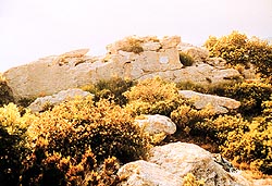 Photo 1.View
of stone complex, discovered by Marcello Dalbuono, taken with a 35 mm.
lens. At the centre is the rock wall, with the plaque to the right and
saddle at the centre. The Pian dei Corsi can be seen behind the saddle,
behind which the Sun effectively sets at the summer solstice. In front
of the rock wall, between the bushes, there can be seen: the stone with
the greater sequence to the right; the squared stone without engravings
at the centre; the stone with the minor sequence to the left. The sheer
rock with the two cross-shapes of fig. 1/c - d is hidden behind the wall,
at the height of the plaque. The Ciappo de Cunche can be found behind
the observer, not in vision.
Photo 1.View
of stone complex, discovered by Marcello Dalbuono, taken with a 35 mm.
lens. At the centre is the rock wall, with the plaque to the right and
saddle at the centre. The Pian dei Corsi can be seen behind the saddle,
behind which the Sun effectively sets at the summer solstice. In front
of the rock wall, between the bushes, there can be seen: the stone with
the greater sequence to the right; the squared stone without engravings
at the centre; the stone with the minor sequence to the left. The sheer
rock with the two cross-shapes of fig. 1/c - d is hidden behind the wall,
at the height of the plaque. The Ciappo de Cunche can be found behind
the observer, not in vision.
A - Description
The story of the discovery of this stone deserves to be briefly remembered.
It can be found in the municipality of Orco-Feglino, that is in the
province of Savona, at 340 m. above sea-level, lat. 44° 10' 43" N long.
8° 19' 59" W, U.T.M. co-ordinate 32TMP46849588 I S.E. It was indicated
the first time in 1965 by Marcello Dalbuono, who was then a seventeen years
old Milanese, member of the International Institute of Ligurian Studies,
staying with his family at Finale during the summer holidays. A reconnaissance,
carried out by the personnel of the local archaeological museum after his
indication, also allowed the taking of a black and white photograph; but
complex circumstances caused the forgetting of the precise location of
the stone, also taking into consideration the fact that, although it was
near to a path, what is more not very frequented, it necessitates the passing
through a section of a very thick wood to be reached. Unfortunately, Marcello
Dalbuono died in 1970. His parents affixed a commemorative plaque in the
vicinity, still in situ, the text of which is as follows:
Quod hic coram inscriptum
est invenit a.D. MCMLXV
MARCELLO DALBUONO
qui natus est XII-II-MCMXLVIII a. D.
obiit IX-VI-MCMLXX a. D.
followed by the superimposed monogram of Christ, "chi-ro" in
Greek letters.
The stone was found again by Prof. Tizzoni, in the years immediately
following, and he described it, summarily, in his fundamental article on
Finalese (Finale Liguria area) engravings (TIZZONI. 1975). Again, however,
the position was lost, until during the Summer of 1988, on request of Dr.
Vicino and, thanks to the precious and indispensable information kindly
supplied by Prof. Tizzoni, I was able to find the exact position.
It concerns a single parallelepiped shaped block of stone with rounded
corners, 280 cm, long having a width between 40 and 60 cm and, a thickness
that varies between 55 cm, and 80 cm. Above all, the first two measurements
refer to the upper surface, facing the sky, the others, especially the
end turned towards W, being smaller by some centimetres: this end, in fact,
is tapered, unlike the end facing E, that is more squared.
The whole block is orientated, with the most squared end, according
to an axis of 61° and of 241°, to that of the most tapered. It
rests on two rocky protrusions from the earth that are a few centimetres
high and placed in the vicinity of the E and W ends, so that the result
is an empty space between the earth and the lower face that is 70 cm, long,
60 cm, wide and 20 - 30 cm, high.
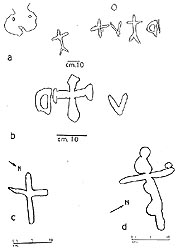
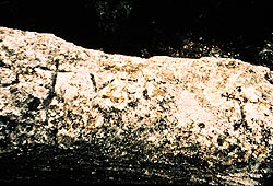
Fig. 1
Photo 2
The upper surface presents a series of engravings (that from here on
I will call "greater sequence") "readable" from E to W (photo. no. 2; fig.
no. 1/a):
1. A small kidney-shaped basin 25 cm, long, 16 cm, wide and 2-3 cm,
deep, from which departs a small duct 4 cm, long, 8,5 cm, wide and as deep
as the basin from which it originates. This duct extends the whole length
of the vertical S surface of the stone, that is equal to 20 cm.
Some characteristics can make one think of its artificial origin:
a) it is the only structure of this type on the whole block of rock;
b) internal sub-marginal concavity characteristic is missing, frequent
in the analogous Karst-formations; on the contrary, it gradually descends
from the upper edge of the wall, towards the basin-bottom with an oblique
course going downwards and from the outside towards the inside.
The group, however, appears to be rather worn.
2. The first bifurcated based cross-shape can be found in an isolated
position between the kidney-shaped basin and the successive group of four
engravings, at 20 cm, from both, 22.5 cm, high and 16 cm, wide with furrows
averaging 1-2 cm, wide and 1-2 cm, deep.
A compact group of signs follow:
3. A "Greek" cross-shape, that is with identical arms, 15-16 cm, long
and the same width, with furrows averaging 1,5 cm, wide and 1-3 cm, deep.
4. A V sign, 9 cm, long and the two ends 10 cm, and 3 cm, wide, respectively,
with furrows averaging 1-1,5 cm, wide and 1-2 cm, deep. This is 1 cm, from
the previous "Greek" cross-shape.
5. An elliptical cup mark with 5 cm, and 4,5 cm, diameters and 2-3
cm, deep, located 10 cm, towards the South of the V sign.
6. A second bifurcated based cross-shape, 25 cm, high 13,5 cm, wide
with furrows averaging 1-3 cm, wide and as deep. It is 5 cm, from the V
sign.
7. A semi-circular sign, of fairly complex structure, with an amplitude
of 80°, a height of 12-14 cm, and width of 12 cm, The furrows are on
an average 1-3 cm, wide and just as deep. Overall, this sign has a surface
between 144 cm2 and 168 cm2, depending on whether a triangular appendix
at the NNW end is excluded or not. We can see farther ahead that is can
also be read as a closed gothic C.
8. Some other signs scattered on the surface of the stone:
a) approximately thirty cup marks of various measurements;
b) a 21,5 cm, long furrow joining three strongly elliptical cavities
together, of 1 cm, 4,5 cm, 2,5 cm, respectively, with another 3 cm, cup
mark next to it although, not touched by the furrow.
The three cross-shapes, the V sign and the semi-circular sign are without
doubt the work of man of all the above mentioned signs.
Of probable human work, in decreasing probability order, are the following:
a) the large cup mark above the V sign;
b) the kidney-shaped basin with duct;
c) some of the other thirty cup marks.
All of the others are of natural origin, without doubt.
Nothing made by hand was found on the surface of the Stone or in the
small surrounding plateau, that is, however, in great part invaded by vegetation.
B) Other neighbouring structures
Another two cross-shapes, although not bifurcated, are engraved on the
rock wall that is facing, on which the plaque is affixed.
One measures 22,5 x 15,5 cm, with 1,5-2,5 cm, wide furrows. Its rounded
forms consent to interpret it as a representation of the body of Christ
Crucified. The longest arm is approximately orientated in the direction
of the Summer solstice sunset. (fig. no. 1/d).
The other measures 14 x 10 cm, with 1-1,5 cm, furrows (fig. no. 1/C).
A second, slightly bigger mass exists near the main mass, with 90°
edges, clear cut and well squared but without engravings on the extremely
rough and irregular surface. The impression it gives is that of work being
started and prematurely interrupted.
A small outcrop of rock can be found about ten meters Eastwards from
the wall with the commemorative plaque, containing an oval cavity with
axes of 35 cm, x 30 cm, 10 cm, deep, with the bottom separated by a kind
of step and a duct that starts from a little higher than the basin-bottom;
it is mainly 8 cm, wide, 150 cm, long and finishes 150 cm, from the ground.
Another basin exists on a different outcrop of rocks approximately 2-3
m. towards SW, It is circular shape with 19 cm, diameter and 6 cm, deep,
has a duct 154 cm, long, 4-8 cm wide, 1-2 cm, deep that starts from a level
a little higher than the basin-bottom, with an outlet approximately 20
cm, from the ground, in correspondence to a corner of the rocky outcrop.
Here I would only like to say, without entering into a discussion that
requires a study apart, that these basins, unable to hold water due to
the duct and furthermore, normally of small dimensions and dug out of the
rock at a certain height from the ground, are, it seems to me, interpretable
as rain water "conveyors", that is, real and proper funnels through which
it was possible to collect, in vessels put at the outlet of the ducts,
"current" rain water and therefore pure. This is the difference between
the basins without ducts, normally of greater sizes and capacities and
dug out at ground level, for the purpose of holding stagnant water and,
consequently, most probably destined for watering of domestic animals.
The origin of the duct from a level a little higher than the basin-bottom
increases their purifying powers acting as a "filter" or "barrier" against
any vegetable residuals.
The "eaves gutter" complex dug out of the "roof" of the Oxen Shelter,
that I identified in 1986 and until then still, as far as I know, unknown
and unpublished, could have had the same function.
Other seven basins can be found on a large rocky horizontal outcrop
a few meters W: these seem to be undoubtedly due to the action of the rain
water.
Another rock containing basins of natural origin but with possible intentional
retouches can be found in the thick wood to the North. It was clearly used
in the past for terracing the ground, together with some low dry walls.
During the course of a recent reconnaissance of Marcello Dalbuono's
Stone, I found a new, unedited, series of three engravings, on another
stone only a few meters away from the first and "against" the rock exactly
at the point where it forms the saddle. Maybe this mass is that <..other,
also engraved and now removed or destroyed...> of which M. Tizzoni speaks
in his work of 1975, at page 9, line 20. This second stone is of an extended
shape and its upper margin, arched and convex towards the sky, is reduced
to a narrow edge, except in one place, near the middle, where it flattens
and widens some centimetres; on this "widening" are engraved the three
engravings, inedited, and, therefore, probably unknown until now.
It deals with a sequence, that from here on I will call "minor", of
three small sized signs but well recognisable in their shape (photo. no.
3; fig. no. 1/b).

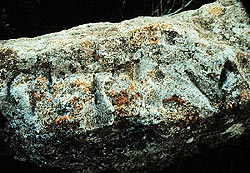 Fig. 1
Photo 3
Fig. 1
Photo 3
From east to west, they are:
a) another crossed letter C, 8 cm, high, 5 cm, wide;
b) another Greek cross, of which the equal length arms finish with
a triangular base (a so-called "evident cross"), 15 cm, high and 13 cm,
wide
c) another letter V: 7 cm, high and width from 1 cm, to 6 cm.
As can be seen, it deals with the same sequence shown, in greater size,
on the M. Dalbuono's Stone, with the difference that, in this last: the
V precedes the crossed C and, a bifurcated cross-shape is interposed between
the two; the Greek cross does not end in a triangle; there is a second
cross-shape at the base and the kidney-shaped basin with duct; the V is
dominated by the large cup mark and; other small cup marks are scattered
over the surfaces.
Considering the shape of the two letters, the "minor" sequence is read
from east to west and from right to left, that is, with one's back to the
saddle in the rock above; therefore, it results that the two sequences
are read in the same sense. Furthermore, this second, inedit sequence of
engravings, appears to confirm, with its iterativity, the importance, maybe
sacred, of the place. At the same time, it decidedly contradicts the hypothesis,
put forward from the beginning of work, by others, for the greater sequence,
then abandoned, of an epistle or small column destined for some Christian
chapel.
C - Archaeo-astronomical aspects
It was very clear, from the first searches, that the rocky rising of
the ground containing these groups of engravings, that is to say the summit
of Mount Cucco, is W of Ciappo de Cunche. It is clearly visible from the
giant mass leaning vertically at an altitude of 364.4 m. that dominates
the Ciappo from S and which opens, from opposite sides, the Oxen Shelter
to the East and the Arma dei Buoi to the West, or, with still more precision,
from the small truncate-conic ground rising, at an altitude of 341.1 m.
above sea-level, that rises at the centre of the Ciappo. From this point,
in particular, I have repeatedly measured with the prismatic compass an
approximate 267° 30' azimuth and a height of the visible horizon (a
mountainous chain in the background, farther away and higher) at 4°
20', corresponding, with good approximation, to the Summer equinox, that,
perfectly visible (photo. no. 4), occurs in the depression of the visible
horizon. This is distant 13,5 km, between M. Grosso (altitude 1268 m. above
sea-level) to N and Bric dell'Agnellino (altitude 1335 m. above sea-level)
to S, in the northern ramification of the M. Carmo di Loano group (SV).
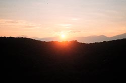
Photo 4 The M. Dalbuono's complex is situated on the rising
of the ground, on the horizon, in the foreground, immersed in the light,
vertically under the solar disc, as indicated by the arrow.
The high mountain to the left is M. Carmo: M. Cucco, on which the engraved
stones can be found, is the only point of bare rock that emerges at the
centre of a thick wooded covering.
My friend, Prof. Enrico Calzolari, during a visit in 1994, suggested
checking other alignments as well. In this way I became aware that, without
counting the lunar, stellar, the so called "Celtic" holidays, etc., there
was at least one other interesting solar alignment: the one indicated by
the saddle, approximately 3° wide, on the overhanging rock to the N
of the engraved stones; it can, in fact, be found approximately 300°
from these, that is towards the sunset azimuth of the Summer solstice.
The magnetic azimuths are shown in Tables 1 and 2, measured at the site
with the prismatic compass and, the geographical azimuths, measured on
the topographic chart, 1: 100 000 of I.G.M.I. and 1: 5000 of the Ligurian
Region, determined near sunset on 21/06 and 25/06/95, respectively.
|
TABLE 1
|
AZIMUTH 21/06/95.
|
|
Relief's
|
Azimuth geographical
|
Azimuth magnetic
|
Difference
|
| M. Carmo di Loano |
252° 30' |
250° 00' |
+2° 30' |
| Alt. 364,4 m. above sea l. |
94° 00' |
97° 40' |
-3° 40' |
| Alt. 400,5 m. above sea l. |
52° 00' |
56° 00' |
-4° 00' |
| M. Croce |
219° 30' |
218° 50' |
+0° 40' |
| M. Settepani |
291° 00' |
288° 00' |
+3° 00' |
| Verezzi bell-tower |
194° 45' |
195° 00' |
-0° 15' |
|
|
|
|
| Total |
1103° 45' |
1105° 30' |
-1° 45' |
Medium azimuth: 183° 57' 30" - 184° 15' 00" = -0°
17' 30"
Medium difference:
-0° 17' 30"
NOTE:
-: western magnetic declination
+: eastern magnetic declination
| Relief's |
Azimuth geographical |
Azimuth magnetic |
Difference |
| M. Carmo di Loano |
252° 30' |
251° 30' |
+1° 00' |
| Alt. 364,4 m. above sea l. |
94° 00' |
92° 30' |
+1° 30' |
| Alt. 400,5 m. above sea l. |
52° 00' |
57° 00' |
-5° 00' |
| M. Croce |
219° 30' |
218° 30' |
+1° 00' |
| M. Settepani |
291° 00' |
287° 30' |
+3° 30' |
| Verezzi bell-tower |
194° 45' |
195° 50' |
-1° 05' |
| M. Bastia |
208° 30' |
208° 00' |
+0° 30' |
| Alt. 341,1 m. a.s.l. |
81° 45' |
88° 00' |
-6° 15' |
|
|
|
|
| Total |
1394° 00' |
1398° 50' |
-4° 50' |
Medium azimuth: 174° 15' 00" - 174° 51' 15" = 0° 36' 15"
Medium difference:
-0° 36' 15"
NOTE:
-: western magnetic declination
+: eastern magnetic declination
The medium difference in the first table between magnetic and geographic
azimuths, on six measurements, is equal to 0° 17' 30; in the second,
on eight measurements, it is equal to 0° 36' 15"; the medium of the
two differences is equal to 0° 26' 52", as can be seen. The magnetic
declination (or variation) is, therefore, less than 1° W in both cases,
with less intensity on 21/06, in respect to 25/06, while its medium, after
96 hours, is less than 0° 30'. This demonstrates, in conformity with
the phenomena of western magnetic drift declination (GUARNIERI BOTTI, 1980),
that magnetic measurement of monuments in archaeo-astronomy is sufficiently
reliable, at least in a speedy way. This is on condition that one is wise
enough to calibrate the measuring instrument first, determining on field
and at the moment, magnetic declination, comparing between them the greatest
number possible of magnetic and geographical azimuths.
In the case being examined, however, the measurements were complicated
by the fact that there is no precise point from where to sight, but only
a small sized clearing. Further complications, the horizon, seen from the
ground - approximately 4 m. lower than the saddle - appears absolutely
clear, while it is enough to climb up to a rocky protuberance only 1 m.
from the ground, or, better still, on the saddle itself, to see the visible
horizon obstructed by the grassy slopes of the protrusions lying behind,
between M. Settepani (alt. 1386 m. above sea level) and the Piano dei Corsi
(alt. 1028 m. above sea level), about the height of the Madonna della Neve
chapel (alt. 937 m. above sea level).
The best solution proved to be, with this uncertainty, visual examination
of the phenomena on 21/06/95. The solstice occurred between 7:00 and 8:00
p.m. on that day, as the sunset was forecast, from the mentioned Nautical
ephemerides, at 7:32 p.m. for latitude 40° N and at 7:50 p.m. for lat.
45° N.
Unfortunately, I was unable to make any observations or take any photographs
on that day due to thick cloud; however, the occasion was presented four
days later, on 25/06 (photo. no. 5).
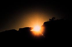 Photo 5
The beginning of the disappearance of the lower edge of the solar disc
occurred at 7.00 p.m.; the medium atmospheric pressure was equal to 977
mb, the temperature 19° C and humidity 27%. Here, as with the equinox,
given the very high zenith distance of the planet (83° 30') the atmospheric
refraction is calculated, not for integration but using appropriate tables
(PROVERBIO, 1989, Tab. 14; NAUTICAL TABLES 1961, Tab. no. 22). I was able
to witness the setting of the Sun on the visible horizon, after climbing
on to the saddle, in this direction. distant 8,2 km The phenomena started
at 7.38.52 p.m. and concluded at 7.42.46 p.m., with the disappearance of
the lower edge of the solar disc. The setting point height was 4° 40'
and its magnetic azimuth 298° 1 / 4.
It is known that the Sun moves at minimum speed at solstices, so much
so, as to appear still for some days (solis statio), before restarting
the inverse way; in spite of the elapsed 96 hours, the movement between
the two data was equal to only 0° 04; 51.98", that is, approximately
1/6 of the movement that happened at the previous equinox in only 48 hours;
it can therefore be declared that the two setting points coincided.
In this way it demonstrates that the Marcello Dalbuono complex has at
least a double alignment:
a) with Ciappo de Cunche and the equinoctial sunset;
b) with the summer solstice sunset.
It is evident, as I will define below, that this double alignment is
natural and in that case the engraved stone complex was erected here, and
not vice versa.
D - Explanatory hypotheses and considerations
Closed C letters have never been found, until now, in the Finalese:
those of the M. Dalbuono's Stone are the first identified; the V letters
are not mentioned either, while the bifurcated cross-shapes are common.
The existence of a sequence of alphabetical letters is, also, an innovation
for the Finalese, because up until now only symbolic signs or modern and/or
contemporary writings have been discovered. A relief of the greater sequence
was submitted for observation by experts operating at the Genoa University
and the International Institute of Ligurian Studies: it resulted that the
two bifurcated cross-shapes are attributable to the Late Middle Ages and
the closed C to the Dark Ages (or early Middle Ages); they could be interpreted
as written letters of the gothic alphabet, introduced in Liguria towards
the end of the XII century - beginning of XIII(2).
Furthermore, it is believed that the greater complex can be interpreted
as a "sign of possession"(3).
So, there does not seem to be excessive difficulty, either on the chronology
or on the purpose of the engravings. However, in my opinion, the function
of the whole complex is much less apparent. It could be a gathering of
erections, all of the same age; but it could also be the remains of a "stone-altar"
type structure, of pre-Christian culture, maybe connected with solar movements
that stress the seasons; successively the monument could have been christianised
with the well-documented system of affixing sacred symbols.
It is well known, for some time now, in a geographical sense, that a
stone structure above the Grotta Strapatente (Giuggiola 1984; Codebò
is in the press.), that could probably be attributed the function of altar,
while another two, of smaller dimensions, were identified by myself, in
1994, in the "Gli Zerbi" locality, not far from the Marcello Dalbuono's
Stone. None of these structures, however, have engravings.
As it is impossible to come to conclusions due to the lack of a deeper
knowledge and systematic archaeological investigations, here I will limit
myself to a series of considerations that could compose the basis for future
research. I will do this only for the Ciappo de Cunche area, although mutatis
mutandis, the same data and reasoning could well suit many other areas
of the Finalese.
For that concerning the old objection put forward by Prof. P. Graziosi,
and more than once repeated (GRAZIOSI, 1935; 1973; 1982), it would seem
that, in reality, the stone from Finale, under the meteoric agent's action,
develops a surface hardening reaction, forming a sort of crust able to
maintain engraved signs for a long time (Dr. Giuseppe Vicino, spoken communication).
A demonstration would be both the mediaeval signs of the Marcello Dalbuono's
Stone, amply exposed to the inclemency of the weather; and the oxen engraved
in pure M. Bego style on the vaults of the Oxen Shelter (FELLA, ZENNARO
1991) and that, on the contrary, can be found in a protected position:
both signs date back to times much more remote to those admitted by Graziosi.
Therefore, there don't seem to be obstacles of geological nature to
the fact that the Finalese engravings can be very ancient (ISSEL, 1889;
1908), in which case the typological affinity would acquire new importance.
The same Oxen Shelter, like its "twin" at a few hundred meters distant
more to the S along the path, seems to be, for the richness of its engravings,
something different from a shelter under rock and living uses, especially
if compared with that of Fascette I or with the Arma dei Buoi. The name
"oxen" could, among others, derive from the bucrane engraved it and then
also transmitted, by extension, to the Arma nearby. In particular, the
Twin Oxen Shelter, more S, does not exceed 1,4 m. in height by 5 m. length
and 1,7 m deep; therefore it could never have offered any possibility of
shelter; in spite of this, its back wall is amply engraved; in fact, the
following can be found:
a) 4 shelf type niches, that, proceeding from E to W, measure 58 14
x 30 cm, ; 60 x 7 x 30 cm, ; 60 x 15 x 24 cm, ; 34 x 10 x 20 cm, in width,
depth and height,
respectively.
b) a "sharp" angle 30 cm, high and 8 cm, deep;
c) a cup mark;
d) a very long "s" furrow, 25 cm, long, 3-4 cm, wide and 1 cm, deep;
e) another sign 10 cm, high and 9 cm, wide at the base and 11 cm, at
the top, that could be interpreted as another bucrane, but upside down,
that is, with the horns downwards (fig. no. 3/b). Furthermore, a large
stone, nearly at the entrance, bears a large Greek cross, probably the
most voluminous in the of the Finalese area, with both arms 35 cm, long,
7-8,5 cm, wide and 1-2 cm, deep, and three cup marks engraved, in their
turn, two on one of the arms and the other exactly at the crossing point
of the same. It is believed that, the Arma dei Buoi, near the Oxen Shelter
and, the Twin Arma dei Buoi, near the Twin Oxen Shelter, are both S shaped,
of such dimensions to offer shelter to more than one person and appropriately
adapted for the purpose, with dry stone walls and, that there is a single
shelf niche engraved for each (that of the Arma dei Buoi is 70 cm, from
the ground and measures 56 x 23 x 32 cm,). The two Shelters, with the richness
of their engravings, that are both facing N and with little or nothing
suitable to give comfortable shelter, suggest rather a function of worship.
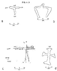 Fig. 3
The finding of Copper Age material near the Riparo Fascette I (MAGGI,
PASTORINO, 1984) demonstrate that the Ciappo de Cunche area was frequented
in the prehistoric era. I, myself, found numerous fragments of pottery,
belong to at least three or four different containers during the spring
of 1995, that, for their characteristics seem to be attributable to the
same epoch. They were all concentrated in a very small area, not more that
1 m2, on the surface of the path leading to alt. 400 m. above sea level;
the location is a very few meters from the top, a few meters from a very
small shelter under rocks and about ten meters above the vertical of Riparo
Fascette I. These fragments are now deposited at the Final Civic Museum.
I would like to point out a curious fact concerning the chronological
attribution of the Finalese engravings: considering that a stratifying
of engravings belonging to different epochs is quite clear, among which,
unquestionably, some contemporaneous letters and the date "1790", the engravings
have been gradually attributed by different Authors, now to recent ages
- at the most "middle ages" - then to "prehistoric" ages, with an evident
exaggerated generalising of chronological terms; but I find that there
has never been considered, not even in hypothetical terms, the possibility
of attributing them to the classical-roman horizontal culture: with this,
a jump equal to at least half a millennium has been made, from the first
Roman penetration in Liguria, during the Punic wars, until the falling
of the Empire; the Roman presence in the Finalese area was, nevertheless,
substantial, as the two necropolises of Isasco and Perti, and the Val Ponci
bridges certify. It therefore appears very strange that the local Ligurian
population, who certainly had to gravitate around the consular roads, did
not express themselves on the rocks for such a long period of time, even
if they were illiterate.
II)Other orientated engravings
A) in the Finalese area
Other astronomically orientated structures are present in this territory.
Among these, the engravings are the following:
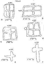 Fig. 2
a) Four quadrilaterals with engraved crosses on the surfaces of Ciappo
de Cunche. Three are Greek crosses and orientated exactly towards the four
cardinal points (fig. no. 2/a, c, d); their measurements are 28 x 30 cm,;
25,5 x 26,5 cm,; 29 x 30 - 21 cm.
The fourth is a Latin cross and not orientated towards the four cardinal
points, from which it diverges by nearly 20° (fig. no. 2/b); it measures
21 x 32,5 cm.
The noting of the orienting of these four engravings is thanks to my
friend Dott. Mauro Fella.
b) Two crosses in the Le Conchette locality, otherwise known as Ciappo
dei Ceci. The greatest (fig. no. 2/f) measures 37 x 23 cm, ; the longest
arm with a medium of 6 cm, is nearly orientated on the meridian axes, at
355°-175°; the shorter is orientated on the equinox axes, at 90°-270°;
the eastern section is 6 cm, wide and the western 7,5-9 cm. This last would
seem to be dealing with a previous quadrangular basin, to which a large
cross was successively superimposed.
The minor (fig. no. 2/e) is a 20 x 20 cm, Greek cross, with a medium
of 3 cm, furrows and 1-2 cm, deep; the crossover of the two arms, however,
was not carried out at the exact half of the respective measurements, so
that it seems displaced in such a way that the south-western quadrant is
greater than the north-eastern. This also is orientated towards the four
cardinal points, with a defect for error of 5°.
c) Two cross-shapes on the rocks in Val Nava identified with number
12 by Tizzoni (TIZZONI, 1975). One is a 31 x 22,5 cm, patent cross (fig.
no. 3/d); the other is smaller and apparently under or superimposed by
a rectangular basin. Both phe engravings are orientated towards the four
cardinal points.
d) A "tau" sign (fig. no. 3/a), on a globular rock situated vertically
on the Val Cornei, along the path of the western ridge of the Val Nava.
Its measurements are: length 11 x 14 cm, width of furrow 2-2,5 cm; depth
1,5 cm. The 11 cm, long arm is orientated on the meridian axes, at 360°-180°,
while that of 14 cm, has a 280°-100° orientation, that is, diverging
10° from the equinoctial axis. It could, however, be a matter of a
sign of the so-called "napoleonic pile".
Which could be the way and the meaning of the orientation of these
engravings? It is possible, only in the case of the four quadrilaterals
engraved on Ciappo de Cunche, at least in part, to invoke the N-S inclination
axis of the rock; this can't be true for Ciappo dei Cedi, that, on the
contrary, is inclined according to the NW-SE axis; neither for the other
two rocks considered, that are almost horizontal. Therefore, it does not
seem very probable that such precise orientations to cardinal points are
due to chance. But, if they are intentional, it is necessary to explain
how and why they were engraved in this way. The answer to the first question
is intrinsically linked to the age to which the engraving dates back to:
if this is modern, it could easily have been carried out with the help
of a compass; if it is ancient, resorting to one of the astronomical methods
well known to the ancient civilisation as well as the less developed populations:
for example, the shadow of the gnomon. better if applied to "Indian ring"
(ROMANO, 1991; 1992; 1994; 1995; PROVERBIO, 1989). The answer to the second
query invests, obviously, the whole cultural - religious - spiritual complex
of the engravings and presupposes, with more reason, precise chronological
attributions; but seeing that these are still missing, also due to the
absence of systematic and deep archaeological investigations around the
Ligurian engravings complexes, I will limit myself to giving a single outline,
that, what is more, finds enormous confirmation in the studies on symbolism
(BIEDERMANN, 1991; CHEVALLIER, GHEERBRANT, 1992) and pre-Columbian Civilization
(ROMANO, 1993); I am referring to the quadripartition of space, in the
archaic Italic templum sense, that <....The ancient Romans originally
indicated the space surrounded by sky used by augur to observe the presages...>
(DEVOTO, OLI, 1967, word "temple"). Reading that concerns this subject
is, now, enormous (DEVOTO, 1977, pages 15-18; TOSI, 1991, pages 74-82;
ROSADA, 1991, pages 88-95; ROMANO, 1991; AVENI, ROMANO, 1994; ROMANO 1995,
chapts. IV - VII).
B) outside of Finalese area
Until now the following engravings have been identified outside this
privileged area of investigations and findings, orientated:
Mr. Luigi Felolo found a stone on Monte Pennone, in the Genoese province,
some of the engravings are directed towards Punta Martin, behind which
the Sun rises at the summer solstice and, towards Monte Bastia, behind
which the Sun rises at the equinoxes (FELOLO, 1994 a; 1994 b).
A stone with a complex cross-shape orientated to the cardinal points
at the Osteria delle Baracche, on the Genoese hills. The finding was made
by Mr. Giuseppe Novelli, who, very kindly showed it to me on the archaeoastronomical
research chart, collectively started recently in Liguria and, carried out
a "frottage" kindly allowing the reproduction here (fig. no. 3/c).
In some panoramic areas of the La Spezia area there exist engravings
that seem to be orientated to non astronomical but geographical azimuths:
they indicate the directions that, on clear days, the outlines of the Capraia,
Gorgona and Corsica Islands are visible; Cap d' Antibes on the Provencal
coast: Monte Argentera (alt. 3297 m. above sea level) and Monviso (alt.
3841 m. above sea level). These engravings, discovered and studied by Enrico
Calzolari, could open a new chapter of study concerning the so-called "route
indicators" (ROMANO 1994 b).
C) Conclusions
The lack of any essential data makes definite conclusion making quite
premature; therefore I will indicate here some of the future potential
research lines.
The orientation of the described engravings would seem an integral cultural
part of the same, that cannot be omitted from their reason to exist and
therefore from every trial of interpretation; this is, obviously, true
if one accepts that such an orientation is intentional against the hypothesis
of casualness; this last, however, appears improbable, considering the
quite high number of orientations found, their substantial homogeneity
and, in particular, between the cross-shapes, as well as their good precision.
Nevertheless, it will be a good idea to carry out a statistical investigation
concerning this in the future, to evaluate in the most objectively way
possible the reliability of results and the probability percentage of the
orientations being casual or intentional.
Unfortunately, as I have already mentioned, certain and homogenous data
on the chronological attribution of the engravings is missing, mainly for
the absolute lack of deeply examining and systematic archaeological explorations:
just to think that it is not yet, officially and formally, ascertained
whether Megalithism penetrated or not in Liguria, although the presence
of typical structures able to be set in it is clearly evident, that is,
together with the engravings, subject of archaeoastronomical investigations
by us (CODEBO', 1993; 1994. FELOLO, 1988; 1990; 1991 a; 1991 b; 1992. MANUGUERRA,
1987. MONACO, 1995). The extension of this type of investigation is also
foreseen for the middle ages' structure, in the future, considering the
results obtained elsewhere in Italy, in this chronological environment
(ROMANO. 1986; 1992; 1995).
Clearly, surface findings can't be studied with the methods actually
in use for those in stratigraphic position, but must be faced with their
own methods and, not leaving the local context out of consideration. In
this way, as in the case of Ciappo de Cunche, it is possible to
be faced with a sit, used at different times during the ages, where the
engravings, the shelters, the pottery deposits, the orientations are the
single components of an "unicum" and, as such, must be evaluated.
It is clear for that concerning Marcello Dalbuono's Stone that, the
two measured orientations are natural: if there is a not casual relation
between them and the two engraved sequences, then these last are certainly
the consequence of the first and not vice versa, in the sense that the
complex "builders" were probably aware of the existence of the double orientation:
a) Ciappo de Cunche - Monte Cucco - sun setting at the equinoxes
b) natural saddle on M. Cucco rock wall - sun setting at summer solstice
and, consequently, the central part of this double alignment was "consecrated",
that is, the M. Cucco's peak, with the stones' altar. Maybe later, in Christian
times (one supposes that the first "consecration" was pagan) the locality
was "sanctified" with the affixing of the new religion's symbols and of
the two letters V and C that, in this case could be the initials of the
phrase Christus Vincit (or Victor) in the minor sequence and Vincit
(or Victor) Christus in the greater.
Maybe the recognition of the double natural alignment and the building
of the respective structures all occurred in Christian times, as also,
might have been the two bifurcated cross-shapes are, in reality, anthropoids
much more ancient. The patent cross, however, is without doubt Christian.
In this place, whatever the chronological stratification of the concerned
structures might be, provided that a casual relationship exists between
orientation and engravings, structures were not erected to identify important
astronomical positions as occurs in the greater part of the archaeoastronomical
structures but, on the contrary, it was the astronomical manifestations
that caused the carrying out of structures for the purpose of highlighting
them. Here also, the phenomena highlighted, so well by Mr. Georg Innerebner,
should have occurred in the first half of this century: contrarily to that
which occurred in the flat regions of Northern Europe, in the mountainous
Italian peninsula the ancient inhabitants already found in the natural
relief's the chrono-calendars indicators and therefore, only had to exploit
them. This is something that has reached our present day, as the numerous
alpine summits show, with names such as "Twelth Summit", "Eleventh Summit",
"Mid-day Stone", etc. The "natural meridian" concerning this can be seen
at Sesto in Val Pusteria (Innerebner 1959, Arborio Mella 1990, pags. 48-49).
It must be said that, as regards the other orientated engravings described
here, if the crosses can, with any probability, be attributed to the Christian
culture (when there are no cadestral signs), the quadrilaterals with engraved
crosses appear much more difficult to interpret. This type of representation
is common in the M. Ego area, associated to various types of ox, therefore
of proved prehistoric age. We also have the bucrane-quadrilateral association
at Ciappo de Cunche with engraved cross-shapes, as I have already
described, on the Oxen Shelter vault. If this engraving is contemporary
to its twins of the Alpes Maritimes, as it would seem, could this also
be true for the orientated quadrilaterals engraved on Ciappo de Cunche?(4).
Mr. Mario CODEBÒ
Istituto Internazionale Studi Liguri
Gruppo Archeologico Ligure
Via Carlo Linneo N°163/22
16159 GENOVA ITALY
NOTES
Editorial needs force me to limit the writing of the text, preventing
me from adequately developing certain points. Due to this, there could
be some obscurity on the concepts explained here, for which I would like
to apologise to the readers. The same applies to the iconography.
I would like to thank Prof. Carlo Varaldo for his explanatory contribution.
I would like to thank Mr. Giovanni Murialdo for his explanatory contribution.
I would like to thank everyone who has in some way contributed to this
work. Among these: Mr. Ettore Bianchi, without his essential contributions
this article would never have come to light; Prof. Giovanni Mennella; Mr.
Giuseppe Vicino and my wife.
--------------------------------------------------------------------------------
BIBLIOGRAPHY
ARBORIO MELLA F. 1990 La misura del tempo nel tempo. Hoepli, Milano.
AVENI A., ROMANO G. 1994. Orientation and Etruscan ritual. Antiquity,
68: 545-563
BIEDERMANN H. 1991. Enciclopedia dei simboli. Garzanti, Milano.
CHEVALIER J., GHEERBRANT A. 1992. Dizionario dei simboli. (VI ed.) Rizzoli,
Milano.
CODEBO' M. 1993. I menhir di
Torre Bastìa. Notiziario C.A.I., Sez. Ligure, Sottosez. Bolzaneto,
11: 30-31.
CODEBO' M. 1994. Le cime, i profili,
le ombre dei monti: calendari preistorici. Rivista della Sezione ligure,
2: 8-11.
CODEBO' M. in press. Le strutture a dolmen del Finalese. Astronomica.
DEVOTO G. 1977. Le tavole di Gubbio. Nuova Sansoni, Firenze.
DEVOTO G., OLI G.C. 1967. Vocabolario illustrato della lingua italiana.
Selezione dal Reader's Digest, Milano.
EFFEMERIDI NAUTICHE 1995. I.I.M., Genova.
FELLA M., ZENNARO D. 1991. Incisioni rupestri nel Finalese: rilevamento
fotografico del Ciappo de Cunche e petroglifi inediti al Riparo dei Buoi,
Finale L. (SV). In: Aa. Vv., Le Mont Bégo: une montagne sacrée
de l'age du bronze. Sa place dans le contexte de religions protohistoriques
du bassin mediterranéen, Tende, Alpes Maritimes (5-11 Jullet 1991):
247-48.
FELOLO L. 1988. I menhir delle Cinque Terre. La Casana, 1: 30-34.
FELOLO L. 1990. Pietre, Notiziario C.A.I. - U.L.E., 4: 6-7.
FELOLO L. 1991 a. Documenti di pietra dell'antico popolamento nell'area
del Beigua. In: Aa. Vv., Antico popolamento nell'area del Beigua. C.A.I.,
Comitato Scientifico L.P.V., Vercelli.
FELOLO L. 1991 b. Archeoastronomia: le streghe di Triora vestali del
Sole ? (parte I). R nì d'àigura, 15: 38-41.
FELOLO L. 1991 c. Archeoastronomia: le streghe di Triora vestali del
Sole ? (parte II). R nì d'àigura, 16: 22-24.
FELOLO L. 1992. Archeoastronomia: le streghe di Triora vestali del Sole
? (parte III). R nì d'àigura, 17: 25-27.
FELOLO L. 1994 a. Un calendario di pietra sui monti di Voltri. Notiziario
C.A.I.-U.L.E., 3:17.
FELOLO L. 1994 b. Le religioni delle antiche pietre. R nì d'àigura,
22: 28-31.
GIUGGIOLA O. 1984. Una costruzione megalitica a Finale. Rivista Ingauna
e Intemelia, n. 1-2, Gennaio-Giugno: 67-69.
GRAZIOSI P. 1935. Le incisioni rupestri di Orco Feglino nel Finalese.
Bullettino di Paletnologia Italiana, 55: 227-233.
GRAZIOSI P. 1973. L'arte preistorica in Italia. Sansoni, Firenze.
GRAZIOSI P. 1982. Introduzione agli Atti del Convegno sulle incisioni
rupestri in Liguria (Genova, 18/12/76). Studi Genuensi, N.S., GENOVA.
GUARNIERI BOTTI L., 1980. Elementi di magnetismo generale e geomagnetismo.
Istituto Geografico Marina Militare Italiana, Genova.
INNEREBNER G. 1959. La determinazione del tempo nella preistoria dell'Alto
Adige. Annali dell'Università di Ferrara, N.S., Sex. XV, Vol. 1,
n. 1: 1-21.
ISSEL A. 1898. Incisioni rupestri nel Finalese. Bullettino di paletnologia
italiana. 10-12: 265-279.
ISSEL A. 1908. Incisioni rupestri. Atti Società Ligure Storia
Patria. 40: 458-484.
MAGGI R., PASTORINO M.V. 1984. Riparo Fascette I. In: Aa. Vv., Archeologia
in Liguria. Scavi e scoperte. II, 1976-1981, Sopr. Arch. Liguria, Genova.
MANUGUERRA M. 1987. Il menhir di Tramonti nel solstizio d'inverno. La
Spezia Oggi, I.
MONACO M. 1995. Astronomia e vecchi sassi. Notizie di Cielosservare,
Notiziario del Gruppo Astrofili Savonesi, 59: 2.
PROVERBIO E. 1989. Archeoastronomia. Teti, Milano.
ROMANO G. 1986. Alcune osservazioni sull'orientamento delle chiese medioevali
e moderne entro la cinta muraria di Treviso. Rivista di Archeologia, 9:
56-58.
ROMANO G. 1991. Le costellazioni: origini e loro utilizzo. Biroma, Galliera
Veneta (Padova).
ROMANO G. 1992. Archeoastronomiz italiana. C.L.E.U.P., Padova.
ROMANO G. 1992-93. I calendari Nahuatl. Atti e Memorie dell'Ateneo di
Treviso, n.s., 10: 115-138.
ROMANO G. 1994 a. Osservazioni degli astri nella preistoria e nella
protostoria. Astronomia U.A.I., nn. 3-4.
ROMANO G. 1994 b. Astronomia nell'isola di Pasqua. In: Aa. Vv. Rapa
Nui, gli ultimi argonauti, Erizzo.
ROMANO G. 1995 Orientamenti ad sidera. Essegi, Ravenna.
ROSADA G. 1991. Divisione agraria, orientamento e suolo. In: Aa. Vv.,
Archeologia e astronomia, Suppl. n. 9 della Rivista di Archeologia.
TAVOLE NAUTICHE 1961. I.I.M., Genova.
TIZZONI M. 1975. Incisioni all'aperto nel Finalese, Liguria. Bollettino
del Centro Camuno Studi Preistorici, 12, Capodiponte (Brescia).
TOSI G. 1991. Architettua e astronomia nel "De Architectura" di Vituvio.
In: Aa. Vv., Archeologia e astronomia, Suppl. n. 9 della Rivista di Archeologia.
Home