The
settlement is made up of three parts:
1.
A small building with quadrangular
plan delimited by dry stone walls;
2.
Two short standing stones, 44
cm apart, placed in front of the south wall of the building;
3.
A standing stone with a natural
hole in its top end vertically fitted in a natural fissure of the ground, about
30 meters away from the building and the other two standing stones.
Natural
Environment and Archaeological Framework
The settlement is
located in an area part of the relic of an old calcareous periplain
(i.e. a low-relief plain which is the final stage of a fluvial erosion,
occurred during times of extended tectonic stability), formed during the
Miocene. Here, the weathering excavated three rivers (i.e. Pora,
Aquila and Sciusa) and an intricate system of underground
waters that created over 400 grottos. Archaeological investigations carried out
in the past decades highlighted use of some of these grottos by the mankind,
since the Lower Palaeolithic. Some of these grottos are located in short
distance from the observatory. These are:
1.
The Grotta
degli Zerbi (Zerbi’s grotto), where some archaeological evidences and
fossil fauna were excavated and dated to the Mousterian;
2.
The Riparo
Fascette I (Maggi, Pastorino,
1984, pp. 171–175) where archaeological evidences
dated to the Copper Age (phase of the Middle Ligurian
Neolithic called del Vaso a Bocca
Quadrata, VBQ, or of the pot with squared mouth) were
excavated;
3.
The Grotta
1 del Vacché (Odetti,
1987a, pp. 129–131), with archaeological evidences dated to the Copper Age;
4.
The Refuge of Bric Reseghe, that was used as a
storage area throughout all the chronologic phase of the VBQ (Odetti, 1987b, p. 132);
5.
The Castellaro
di S. Bernardino: a prehistoric settlement on the top of the St. Bernardino
hill that can be dated to the Bronze Age (Del Lucchese,
1987, pp. 133–135 and personal communication of
the same author with one of the authors of this study).
Large
concentrations of petroglyphs are located in areas such as Ciappo de Cunche, Ciappo dei Ceci (also
known as Le Conchette;
Priuli, Pucci, 1994, pp. 35–43) and at Mount
Cucco (Codebò, 1996, pp. 138–141). Unfortunately, none of these petroglyphs can be dated
accurately since there are no comparison of known age in the area for such type
of rock art (Issel, 1908,
pp. 467–484; Giuggiola, 1973, pp. 111–167; Tizzoni, 1976, pp. 84–102; Leale Anfossi, 1976, p. 18–27; Studi Genuensi, 1982, pp. 1–84; Odetti,
Ravaccia 1988, pp. 13–15.; Fella, Zennaro,
1991, pp. 247–248; Priuli, Pucci,
1994, pp. 35–55; Codebo’, 1996, pp. 138–141; Codebo’, 1999).
At the north and south ends of
the mountain ridge are located two Romanesque churches: St. Lorenzino
and St. Cipriano. The latter was in connection with
the medieval settlement of Lacremà, currently
abandoned. After detailed studies, the church of St. Cipriano
revealed an early Christian apse (Frondoni, 1990, pp.
423–426) that was probably an influential point of the Julia Augusta. This was
an important Roman road built by the Emperor Augustus since the 13 B.C. to
connect Rome with the southern Gaul. Important remains of this road are the
five bridges in the Ponci’s
Valley, in very good conditions still now (although they were re-built at the
time of Emperor Adrian).
From an archaeoastronomical point of view, the same ridge hosts
some important evidences such as:
1.
Some cruciform petroglyphs at Ciappo de Cunche (fig. 1) and at Ciappo dei Ceci
(fig. 2), oriented according to the main cardinal points (Codebò,
1997a, pp. 735-751);
2.
The Pietra
di Marcello Dalbuono (the Marcello Dalbuono’s stone), showing two solar orientations: toward
the equinoctial sunset and the summer solstice sunset (Codebò,
1999);
3.
The Camporotondo’s
cromlech (Codebò, 1997a, pp
735-751), currently under investigation by two of the authors of this paper.
The cromlech shows three corners interrupting a circular profile. Two of the
corners are oriented toward the cardinal points north and south, respectively.
Figure
1. Cruciform petroglyphs at Ciappo de Cunche (copyright Mario Codebò).
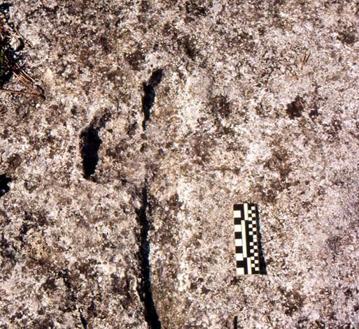
Figure 2. Cruciform petroglyphs at Ciappo dei Ceci (copyright Mario Codebò).
Archaeological
Evidence at Bric Pinarella
The building at Bric Pinarella is the largest
evidence of the settlement. Currently, its structure can be described as a
ruined hut related to a type of buildings locally called caselle (plural; casella
singular). The building has a rectangular plan about 10 m long and 6 m wide
(fig. 3). Wall’s orientation is as follow:
East wall: 346°↔171°;
West wall: 346°↔173°;
North wall: 243°↔61°;
South wall: 235°↔78°.
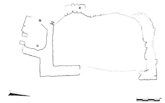
Figure 3. Plan of the building at Bric
Pinarella. Black dots near the south and west walls
provide the position of the trees. The single line in the east wall is used to
suggest the inner alignment (the wall was covered by debris at the time of the
survey; survey G. Pesce)
Thickness of the
north and east walls measured on their top is of about 0.85 m, whereas the
south wall is about 1.10 m thick (thickness of the west wall at the time of the
survey could not be measured precisely because of some debris covering its
central part). Space available inside the building is about 8 m long and 4 m
wide.
No openings such
as doors or windows are currently visible in these remains. However three
vertically aligned stones in the inner front of the south wall suggest
existence of an interruption in the fabric of the wall (fig. 4) that could be
related to an opening (such as a door) or a corner of an earlier layout of the
building (which, in this case, could have had at least two building phases).
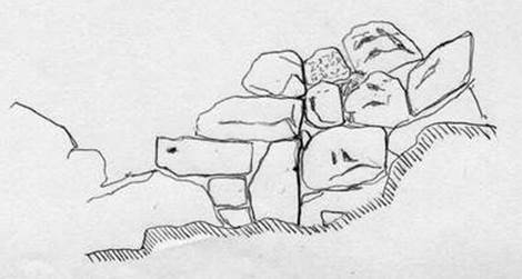
Figure 4. Sketch of the elevation representing the interruption in the fabric
of the south wall that could be related to an opening (such as a door) or a
corner of an earlier layout of the building.
Walls are
preserved for up to 2 m above the ground and are made of stones of various
sizes, laid without mortar (fig. 5). Stones were sourced locally and used
without specific preparation. Stone alignments within the walls are irregular
and characterized by a high number of voids. Cornerstones are generally bigger
than the other stones. Overall, the building technique can be described as
inaccurate and attributed to non-specialized builders.
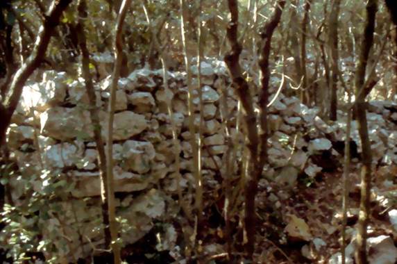
Figure 5. East wall of the "casella"
built without the use of mortar (copyright Mario Codebò).
The south space
outside the casella
is occupied by two walls about 65 cm thick, built almost perpendicularly to the
south wall of the main structure. All together, these walls surround an area of
1.85 x 2.42 m, which is adjacent to the main compartment of the building but
inaccessible from it. The only access to this small space was probably located
in the south side, currently partially destroyed. The only existing remains on
this side of the construction are two short standing stones 0.44 metres apart
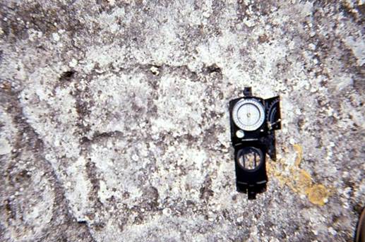
that stand out from the rest of the walls (fig. 6).
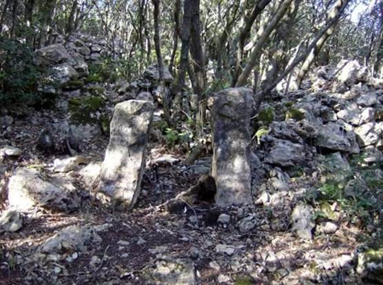
Figure 6. The
two standing stone located near the southern wall of the building in figure 3.
The stones are 44 cm apart (copyright Alfredo Pirondini).
The space between
these stones is too small for being crossed by an adult human being.
Nevertheless, it cannot be ruled out that the small compartment outside the
main building was functional to the activities taking place in the adjacent
structure.
With the goal of
dating the building, the area inside the main compartment close to the east
wall (where archaeologists supposed that some archaeological evidence could
have been found), was archaeologically investigated by Angiolo
Del Lucchese (archaeologist and director of the Soprintendenza Archeologia della Liguria) together with the archaeological practice
"G. Viarengo". Unfortunately, the
excavation did not produce evidence of anthropic origin so that, to date, no
chronological information is yet available on the use or on the construction
time of this structure. Difficulties in investigating the archaeological
context in the whole area of Finale Ligure are very
common. This is due to the karstic nature of the soil and to the erosive action
of the rain that, except for the grottos, easily washes away and mixes the soil
and, with it, the archaeological and geological record. An example of this
effect (called debitage
by French archaeologists) is the record found during the archaeological
excavation of the site of St. Antonino of Perti carried out by Prof Giovanni Murialdo
and dated to the Late Antiquity. In this site, archaeological evidences from
the Mousterian Age (Middle Palaeolithic) were found mixed with materials from
the Bronze Age and with materials from Byzantine Age, in a single stratum of
few centimetres thickness.
About 30 m
southeast from the casella
is located a large rocky outcrop characterized by a fracture some centimetres
wide and several centimetres deep, cutting through the hole outcrop. This is at
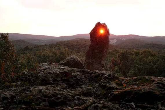
the edge of a steep slope facing east toward the upland plain of the Mànie. The fracture hosts an isolated standing stone with a
hole in its top end (fig. 7). According to the former curator of the Civic
Archaeological Museum of Finale, Mr Giuseppe Vicino,
who surveyed the site several times, the fissure, the standing stone and the
related hole are of natural origin and acquired their characteristics because
of the chemical and geological composition of the stone, called Pietra del Finale. Geologist Dr Davide Gori, who inspected some
photographs of the outcrop, confirmed the natural origin of the fissure.
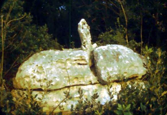
Figure 7. Standing stone vertically fitted in a natural
fissure of the rock with a natural hole in its top end. This stone is about 30
meters away from the building in figure 3 (copyright Mario Codebò).
However, despite
the natural origin of the three elements, arrangement of the standing stone in
the fissure and placement of the hole at its free end cannot be considered
natural. This is confirmed by the presence of a stone fragment at the bottom of
the standing stone, used to fix it in the fracture. Presence of this fragment
suggests that insertion of the standing stone in the rock is, actually, of
anthropic origin.
Astronomical
Functions
First person to
point out an astronomical alignment of the standing stone overlooking the
upland plane of the Mànie was Mr Pino
Piccardo, an associate of the Civic Archaeological
Museum of Finale Ligure (Mr
Giuseppe Vicino, personal communication with one of
the authors of this paper). Mr Piccardo found that the
hole in the standing stone, frames the point where the Sun rises during the
equinoxes. To confirm this observation and verify further astronomical functions
for the whole site, Mario Codebò carried out a full archaeoastronomical survey from 21st to 23rd
March 2003.
Measurements
taken with a prismatic compass Wilkie of the
horizontal arch visible through the hole when the compass sight is placed
against the hole (e.g. fig. 8) is 74° – 93°.
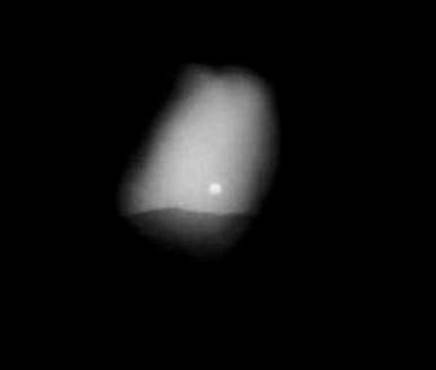
Figure 8. The sunrise on
23rd March 2003, photographed with the camera’s lens against the
hole (copyright Mario Codebò).
This implies that
the sunrise can be seen from approximately mid-March to mid-April and from mid-September
to mid-October. However, observation of the same horizontal arch from short
distance (i.e. with the compass sight not against the hole) allows seeing the
sunrise only at the equinoxes. In such conditions, the Sun looks like a point
of light as represented in figure 9.
Figure
9. The point of light created by the sun
when observed through the hole from some distance from the stone and at the
equinoxes’ sunrises (copyright Sara Pelazza).
All astronomical
functions identified within the site during this study are listed below:
The
hole in the standing stone allows identification of the sunrise at the
equinoxes on the skyline of the Mànie upland.
1.
The sunrise during the rest of
the year (i.e. between two solstices) is clearly visible on the Manie’s horizon from the location of the standing stone
(although outside the hole). The hole in the standing stone allows
identification of the elongation of the Sun from the east cardinal point.
2.
The two standing stones in
front of the south wall of the casella allow
identification of:
a.
The Sun’s upper
meridian transit and, therefore, the moment of the true noon (fig. 10).
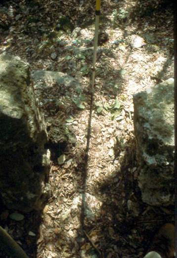
Figure 10. Shadow of the gnomon when it is positioned in
between the two standing stones represented in figure 7. At the time in which
this image was taken, the time of the local (or true, or astronomical) noon was
12:33:22 on 23rd March 2003 (local const.: 12:26:40; equation of
true time on 23rd March 2003: +06:42; copyright M. Codebò).
b.
The different
altitudes of the Sun during its meridian transit, through the four seasons. By
correlating the various altitudes of the Sun with the elongations of the two points of sunrise between the two solstices,
it would have been possible to identify the width of the diurnal arc of the
Sun. This arch is minimum during the winter solstice (when the Sun’s meridian
altitude is at its minimum and the rising point is the southern) and is maximum
during the summer solstice (when the Sun’s meridian altitude is at its maximum
and the rising point is the northern). At the equinoxes, when the Sun rises
within the hole of the standing stone, the related meridian altitude is
intermediate. Theoretically, it would have been possible to measure also the
obliquity of the ecliptic, if precise tools for Zenith measurement were
available.
c.
The Moon’s upper
meridian transit.
d.
The daily delay of
about 50 minutes of the Moon transit over the local meridian, compared to any
star.
e.
The difference between
the sidereal month (27.32 days) and the synodic month (29.5 days).
Conclusions
This study
demonstrates the uniqueness of the remains at Bric Pinarella. This observatory is located in an area (called Finalese) that
has been populated since the Lower Palaeolithic and therefore has accumulated a
rich archaeological record. The few but distinctive remains still visible on
site do not allow dating the settlement but provide unequivocal evidence of the
interest and of the tools used in the past to study the movement of celestial
bodies.
In fact, although
the age of the archaeological evidences at Bric Pinarella is still unknown, it is possible to suppose that
the site was used as a rudimentary astronomical observatory: a kind of
elementary Greenwich astronomical observatory along the northern coast of the
Mediterranean Sea.
We hope that
these findings will foster new archaeological investigations in particular
aimed to date this ancient site that possesses characteristics to some extent
unique (at least in Italy) since it allowed the simultaneous measurement of the
most important astronomical times: the daily ephemerides.
Acknowledgments
Authors are grateful to
everyone who contributed to this research and, in particular to: Davide Gori; Angiolo
Del Lucchese; Tiziano Mannoni; Pino Piccardo;
Giorgio Viarengo; Giuseppe Vicino.
Thanks are also due to Mr. Lorenzo Carlini, Ms. Sara Pelazza and Mr. Alfredo Pirondini
for having granted the right to publish their photos.
Notes
According to the
requirements of the Italian Universities, we declare that, although this paper
is the product of a collaborative work, "Introduction" and the
section "Natural environment and archaeological framework" were
written by H. De Santis; section "Archaeological
evidences" was written together by H. De Santis
and G.L. Pesce; section "Astronomical
functions" was written by M. Codebò.
References
·
Codebò, 1996 – Codebò, M. Segnalazioni inedite
sul Monte Cucco nel Finalese. In: Bollettino
del Centro Camuno di Studi Preistorici, 29, Edizioni del Centro, Brescia, Italy, 1996, pp. 138–141, http://www.archaeoastronomy.it/segnalazioni_inedite_monte_cucco.htm.
·
Codebò, 1997a – Codebò, M. Prime indagini archeoastronomiche
in Liguria. Memorie S.A.It., 1997, 68(3), Italy, pp. 735-751,
http://www.archaeoastronomy.it/prime_indagini_archeoastronomiche.htm.
·
Codebò, 1997b – Codebò, M. Problemi generali dell'indagine archeoastronomica. In Atti del I Seminario A.L.S.S.A., 1997, Genova, Italy, http://www.archaeoastronomy.it/corso_elementare_archeoastronomia.htm.
·
Codebò, 1999. – Codebò, M. Archaeoastronomical
hypotheses on some Ligurian engravings. In: I.F.R.A.O. Proceedings of the World Congress
of Rock Art News95, Centro Studi e Museo d'Arte Preistorica
Ce.S.M.A.P., Pinerolo (TO),
Italy, 1999, CD–Rom, http://www.archaeoastronomy.it/archaeoastronomical_ipoteses.htm.
·
Codebò, 2010
– Codebò, M. L'algoritmo giuliano del Sole. In Atti del XII Seminario A.L.S.S.A.,
Genova, Italy,, http://www.archaeoastronomy.it/algoritmo_sole.htm
.
·
Codebò, 2013 – Codebò, M. Il metodo
nautico. In Atti del XV Seminario
A.L.S.S.A., Genova, Italy, http://www.archaeoastronomy.it/Metodo_nautico.htm
.
·
Codebò, 2015 – Codebò, M. Dall'altezza
misurata all'altezza vera. In Atti del
XVI Seminario A.L.S.S.A., Genova, Italy, http://www.archaeoastronomy.it/altezza_misurata_vera.htm
.
·
Codebò, De Santis, Pesce, 2011 – Codebò,
M.; De Santis, H.; Pesce, G.L. L'osservatorio in pietra di Bric Pianarella
(SV). In Astronomia culturale in Italia,
edited by Società Italiana di Archeoastronomia, Milano, Italy, 2011, pp.
177–185, http://www.archaeoastronomy.it/BricPianarella.htm
.
·
Del Lucchese, 1987 – Del Lucchese, A.
Bric Reseghe. In Archeologia in Liguria
III.1: Scavi e Scoperte 1982–1986, Tormena, Genova, Italy, 1987, pp.
133–135.
·
Fella, Zennaro, 1991 – Fella, M.;
Zennaro, D. Petroglifi inediti al Riparo dei Buoi. In Atti del Convegno su M.
Bégo, Tende, France, 1991, pp. 247–248.
·
Frondoni, 1990 – Frondoni, A.; S.
Cipriano, Campagna di scavo 1986. In Archeologia in Liguria III.2: Scavi e
Scoperte 1982–1986, Tormena, Genova, Italy, 1990, pp. 423–426.
·
Giuggiola, 1973 – Giuggiola, O. Le
incisioni schematiche dell'Arma della Moretta. In: Rivista di Studi Liguri,
XXXIX, Bordighera, Italy, 1973, pp. 111–167.
·
Issel, 1908 – Issel, A. Liguria
preistorica. In Atti della Società Ligure di Storia Patria, XL, Genova, Italy,
1908, pp. 467–484.
·
Leale Anfossi, 1976 – Leale Anfossi, M.; Il Ciappo del Sale.
In Mondo Archeologico, 9, Firenze, Italy, 1976, pp. 18–27.
·
Maggi, Pastorino, 1984 – Maggi, R.; Pastorino,
M.V. Riparo Fascette I. In Archeologia in
Liguria II: Scavi e Scoperte 1976–1981, Tormena, Genova, Italy, 1984, pp.
171–175.
·
Odetti, 1987a – Odetti G.; Grotta I del
Vacché. In Archeologia in Liguria III.1:
Scavi e Scoperte 1982–1986, Tormena, Genova, Italy, 1987, pp. 129–131.
·
Odetti, 1987b – Odetti, G.; Riparo del
Bric Reseghe. In Archeologia in Liguria
III.1: Scavi e Scoperte 1982–1986, Tormena, Genova, Italy, 1987, p. 132.
·
Odetti, Ravaccia, 1988 – Odetti, G.;
Ravaccia, C.; Aggiornamento sulle incisioni del Finale. In: Atti del II
Convegno sulle Incisioni Rupestri in Liguria, Millesimo (SV), Italy, 1988, pp.
13–15.
·
Priuli, Pucci, 1994 – Priuli, A.; Pucci,
I. Incisioni rupestri e megalitismo in
Liguria. Priuli & Verlucca, Ivrea (TO), Italy, 1994.
·
Studi Genuensi, 1982 – Atti del convegno
sulle incisioni rupestri in Liguria. In: Studi Genuensi, NS, Genova, Italy,
1982, pp. 1–84.
·
Tizzoni, 1976 – Tizzoni, M. Incisioni
all'aperto nel Finalese. In: BCSP, 13–14, Capo di Ponte (BS), Italy, 1976, pp.
84–102.
© This article is an open access article distributed under the terms and
conditions of the Creative Commons by Attribution (CC-BY) license (http://creativecommons.org/licenses/by/4.0/).
Torna all’indice cronologico.
Torna all’indice tematico.
Torna
alla pagina iniziale.